The Salt Flats at Ses Salines: Reading a Working Landscape
Ses Salines is not simply a bright stretch of water beside the sea. Its character comes from the managed movement of water, the terrain that holds it, and the work that turns salt into a visible part of Ibiza’s landscape.
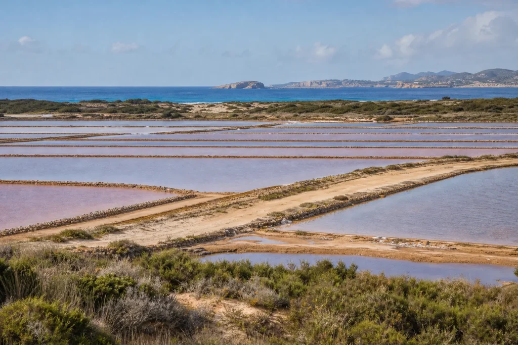
The common mistake at Ses Salines is to treat the salt flats as a blank backdrop: a few pale pools glimpsed on the way to the beach. That shortcut costs you the thing that makes the place legible. These are working ponds, shaped by water, earth and careful management, with the sea close enough to influence them but not simply interchangeable with it.
How you read the landscape depends on why you have come. A visitor with an hour, a walker looking for the relation between the wetlands and the coast, and someone hoping to understand salt production should not make exactly the same choices. The useful approach is to decide what you want to notice, then give the ponds and their boundaries your attention rather than treating every view as the same view.
Do you have time for only a brief stop?
If your time is short, choose a public place where the ponds can be seen without stepping into work areas or disturbing the wetland. The view is best understood as a sequence of contained basins, channels and embankments, not as one uninterrupted sheet of water. Look for differences in water level and color, then notice how the raised edges divide one pool from another.
Those divisions are functional. Salt production depends on moving seawater through a managed system, allowing it to evaporate and become more concentrated before it reaches the final stages of the process. The ponds are not all doing the same job at once, so a change in color or depth can reflect a change in conditions or purpose, not a decorative choice.
Stay with one view long enough to distinguish water from the pale banks around it. From a distance, the hard edges can seem almost drawn; closer attention shows that the terrain itself is part of the equipment. The basin holds water, the embankment keeps it in place, and the channel provides a route through the working landscape.
If you have only a few minutes, follow the edges with your eyes before taking another photograph.
Are you trying to understand how the salt works?
For a closer reading of production, start with the movement of water. Seawater enters the system and passes through linked ponds, where sun and wind remove water by evaporation. As the brine grows more concentrated, it can be directed onward through the stages that lead to salt harvesting. The exact appearance of the ponds changes with the season, weather and work schedule.
This is why “salt flat” can be a misleadingly simple name. It suggests a level field, perhaps dry and white, when the actual landscape includes water at different stages, dividing banks, channels and areas of exposed ground. The contrast between a full pond and a dry-looking bed is not a contradiction. It is part of a process whose visible form shifts over time.
Imagine you arrive after a period of dry, sunny weather and see a shallow pond with a strong color against a pale bank. The sensible reading is not that the water has been dyed for visitors; it is that light, depth, salinity and the conditions in the pond are affecting what you see. A later visit under cloudier conditions might make the same basin look entirely different, while its role in the system remains much the same.
Do not infer the production stage from color alone. Use the channels, embankments and relationship between neighboring ponds to understand how the whole arrangement works.
Do you want to read the terrain around the ponds?
If the landform interests you more than the production process, pay attention to what contains the water. Ses Salines sits within a low coastal setting, where modest changes in elevation matter. The shallow basins, narrow banks and routes for water are shaped by the available ground; the working landscape fits into the terrain rather than replacing it with a featureless industrial surface.
The nearby sea is a source of water and a strong presence in the landscape, but the salt ponds are not simply a natural lagoon. Their divisions and water routes reflect human management. The result is a landscape in which natural conditions and practical construction are difficult to separate cleanly: the setting makes the work possible, and the work gives the setting its distinctive geometry.
Look outward as well as down. The low, open profile of the flats creates a marked contrast with higher ground and coastal vegetation around them. A line of scrub, a distant rise or the edge of a road can make the shallow pools easier to read because each supplies a scale and boundary. Without those cues, the ponds may seem like isolated patches of color.
For this kind of visit, choose a legal public viewpoint that lets you see the relation between pond, bank and surrounding land. A map can help you orient yourself, but the shape of the terrain is clearer on the ground.
Are you visiting for the wetlands and wildlife?
If your main interest is the wetland environment, treat the ponds as habitat as well as working water. The shallow, changing conditions attract birdlife, and the surrounding landscape offers places to feed, rest or move between wet and dry areas. What is present varies with season and conditions, so a quiet visit is more useful than expecting a particular sighting.
Bring binoculars if you have them, and remain on permitted routes. Keep voices low, avoid approaching birds for a closer view, and do not enter restricted ponds or cross embankments that are part of the working system. A phone camera is not a reason to leave a path; the bird will remain a bird, while the visitor may become a problem.
Salt production and wildlife are not separate stories here. The managed water creates a shifting set of conditions, while the wider wetland links the ponds to the coast and surrounding habitats. That does not mean every area is equally suitable for wildlife at every moment, or that a working site should be treated as an open nature trail. It means the landscape is doing more than one job, and those jobs require some care from visitors.
If a bird moves away, give it space rather than following it along the water’s edge.
Are you choosing between a landscape stop and a beach visit?
Choose the salt flats when you want to notice how Ibiza’s coast is organized and used. Choose the beach when your purpose is swimming, sun and time by the water. The two experiences can sit near each other without being the same experience, and trying to turn the salt ponds into a beach detour usually leaves both places only partly understood.
For a landscape-focused visit, arrive with enough time to look rather than merely pass through. The flats reward attention to small distinctions: a channel meeting a pond, a bank holding its line, or water changing in appearance from one basin to the next. There is no need to seek a dramatic overlook. The character lies in the repeated forms and in how they relate to the low coastal ground.
If you are combining the flats with a coastal outing, plan around access and local rules rather than assuming you can wander freely between every visible feature. Some areas are working or environmentally sensitive. Follow signs, use public access points and leave the salt infrastructure undisturbed.
How should you behave in a working landscape?
Keep to public paths and viewpoints, and treat channels, banks and equipment as working infrastructure. Do not take salt from production areas, enter closed sections, or leave rubbish beside the ponds. These are small courtesies with practical consequences: they protect the work, reduce disturbance and keep a visitor from turning a useful view into an avoidable nuisance.
Check local access information before setting out, especially if you plan to walk beyond the most obvious public viewing areas. Conditions and restrictions can change, and a route shown on an old map may not be appropriate now. If a barrier or sign closes a path, take it at face value rather than looking for a clever way around it.
For a first visit, choose the public viewpoint that best matches your purpose: a broad view for the layout, a permitted walking route for the relation between wetlands and coast, or a brief stop for the ponds’ changing colors. Then look for the water’s route and the land that holds it. That is enough to make Ses Salines more than a bright patch beside the road, and it leaves the working landscape intact for the people and wildlife that depend on it.
Stay with the subject

The Sound of a Festive Gathering
At an Ibizan village celebration, music is not a show placed in front of a crowd.…

The Village Square After the Shops Close
On Ibiza, the village square shifts from practical thoroughfare to shared room as the day slows.…